Military Survival GPS FREE - Land nav compass, Tactical GPRS Tool and Altimeter Specifications
|
"LOST" isn't in our vocabulary!! and it shouldn't be in yours either! LAND NAVIGATION has never been easier. Plug in your GRID and your good to go....
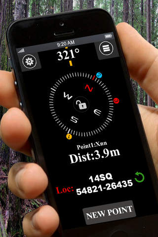

FromStoreboughtmilk:"LOST" isn't in our vocabulary!! and it shouldn't be in yours either! LAND NAVIGATION has never been easier. Plug in your GRID and your good to go. Then just follow the compass to your point! Military Survival GPS is one of the worlds first land navigation app built specifically with hikers, survivalists and hunters in mind and allows the apps user to be guided back to set waypoints using real time compass feedback that displays multiple waypoints at a time right on the compass! There is NO NEED to buy an expensive GPS or backtrack device. Simply download our app, and you'll always have your GPS with you! Get real time 10 digit grids (MGRS) from any location with no internet needed! Visually see your waypoints on your compass and see the direction and distance to them (your compass will literally lead you right to your set waypoints and tell you the distance to them) Military Survival GPS provides live location status in 16 different forms and is updated every 3 seconds. PRO Features include:-Ability to manually enter in MGRS grids for land nav points, objectives or caches
Download (2.02MB)
Always remember your current or found favorite locations by giving the locations a useful name e.g. 'Our School', 'My Favorite Restaurant', 'My...
Accurately measures walking or riding distance, using your mobile GPS.This is a universal app, buy it once, use on the iPad, iPhone and iPod Touch....
Get the eclipse circumstances, distance, direction to the central line according to GPS location.
Use LeeEvac to find your hurricane evacuation zone in Lee County, Florida, before a hurricane strikes!Use your current GPS location, tap on the...
This is an outdoor travel, outdoor up to the necessary software, so you get the fastest speed to the location of the location, GPS location...