Raster Navigational Charts.
A nautical chart is a work area on which the navigator plots courses, ascertains positions, and views the relationship of the ship to the surrounding area.
Raster Charts contain all critical corrections published in notices to mariners since the last new edition of the chart was released, as well as any newly compiled routine changes
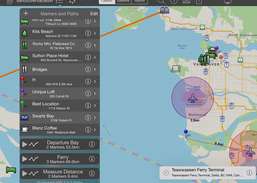
Map Features:
Interactive map that enables users to ...
Redirecting to a secure site. We are checking If the link is working. Please wait...
You can report broken links into broken@dailydownloaded.com. Our editors will review them shortly.
Present live maps and satellite imagery from any iPad to a TV or projector! MapProjector lets you create unlimited maps with labeled landmarks and...
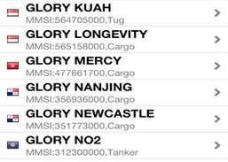
Find any ship all over the world!With FindShip, you can track the movements of your ships realtime on the map.Features:* Nearly 80,000 ships...
Use LeeEvac to find your hurricane evacuation zone in Lee County, Florida, before a hurricane strikes!Use your current GPS location, tap on the...
Get the App. Get the Map. Avenza Maps is a powerful, award-winning offline map viewer with a connected in-app Map Store to find, purchase and...
Find rare pokemon in your area.
Sample map designs for "clash of clans"there are 200+ map designs.note this is not the game/ a game, this app contains sample maps for a better...