User rating |
||||||||
RadarScope Specifications
|
RadarScope is a specialized display utility for weather enthusiasts and meteorologists that allows you view NEXRAD Level 3 radar data along with...
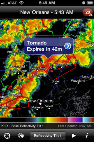
RadarScope is a specialized display utility for weather enthusiasts and meteorologists that allows you view NEXRAD Level 3 radar data along with our most requested new feature, Tornado, Severe Thunderstorm, and Flash Flood Warnings issued by the National Weather Service. It can display the latest reflectivity, velocity, and other products from any NEXRAD radar site in the United States, Guam and Puerto Rico. These aren't smoothed PNG or GIF images, this is real Level 3 radar data rendered in its original radial format for a high level of detail. This version *now includes* support for Hawaii, Alaska, and Guam!Whether you are scanning reflectivity for a mesocyclone's tell-tale hook echo, trying to pinpoint the landfall of a hurricane's eye wall, or looking for small features like velocity couplets in the storm relative radial velocity product, RadarScope gives you the power to view true radial NEXRAD weather radar on your iOS device. When there are any Tornado Warnings (outlined in RED), Severe Thunderstorm Warnings (YELLOW polygons), or Flash Flood Warnings (GREEN polygons) in effect throughout the US, tap the warning button in the top right corner to browse the list of current warnings, view the details, and even zoom to the selected warning on the map. Pinch or stretch to zoom in and out. Drag your finger around the map to scroll. Tap the radar sweep button in the toolbar to switch radars. Select one of the 155 different radar sites, with the rotating radar beam representing each radar's approximate coverage area. Plot your current location by tapping the location button and optionally report it to the Spotter Network. Tap the play button to download and animate over the last six images. Display the names of over 25,000 cities and towns on the map as you zoom and scroll. Tap and hold the color legend to see the data values. Meanwhile, RadarScope will retrieve and display updated data automatically and intelligently (approximately every 5 to 10 minutes, depending on the radar scan strategy). You can display data from NOAA's public access web site, our optional commercial feed provided by iMapWeather (the default), or your Allison House subscriber account. Please visit our web site for more information.
Download (5.4MB)
This aviation weather app brings professional weather forecasting features to every serious pilot.
My weather radar provides you with real-time, accurate weather radar information on the world.