MaxSea TimeZero Marine Navigation Specifications
|
MaxSea TimeZero is a real-time marine chart app for real sailors. More than 95.000 TimeZero users worldwide cant be wrong!MaxSea TimeZero is the...
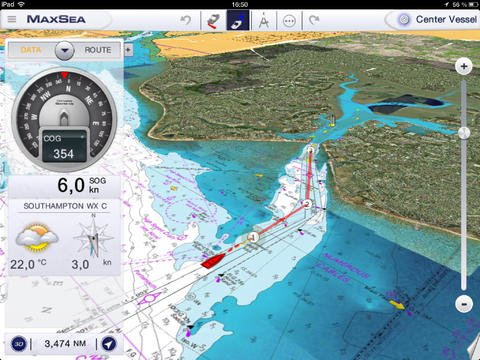
MaxSea TimeZero is a real-time marine chart app for real sailors. More than 95.000 TimeZero users worldwide cant be wrong!MaxSea TimeZero is the best marine navigation app for coastal sailing, featuring easy-to-use functionalities and the fastest and smoothest chart display ever, as well as 3D data and weather information for an unparalleled experience. MaxSea TimeZero is powered by the amazing TimeZero technology, featuring a 2D/3D chart display, PhotoFusion and the most accurate marine charts thanks to MapMedia's unique Raster mm3d format.BASIC FEATURESPosition on the raster chartCourse (COG) & speed (SOG)Routes and marksTrack recordingReal-time local weather and weather trendsNavigation in 2D or 3D PerspectiveTides and Currents databasePlot your position in real-time on the marine charts thanks to the built-in geolocation features of your iPad such as GPS and/or WiFi.Our powerful 3D chart engine allows you to scroll, zoom and rotate the outstanding MapMedia Raster charts in no time.With the MaxSea TimeZero App, you can easily create waypoints and routes, overlay tidal information and satellite photos for a more complete display and configure your NavData panel to keep on screen the specific instrument readings that are most useful to you: COG, SOG, Pos, Accu., CTS, NEXT, TTG, DTW, XTE, VMC, ETA, TTA, DTA and Weather.Go from one waypoint to another (Go to tool), choose the course (Course up or North up), go back to your vessel (Center On vessel) and switch from 2D to a 3D full view in just one click.HIGHLIGHTS 2D/3D chart engine PhotoFusion MapMedia Raster mm3d charts Create and keep up to 20 routes on screen Go to tool Undo/Redo tool Share on FacebookA real-time marine chart app for real sailors!
Download (53.46MB)
Worlds Most Popular Marine & Lakes App! A favorite among cruisers, sailors, fishermen and divers. Find the same detailed charts as on the best GPS...
Worlds Most Popular Marine & Lakes App! A favorite among cruisers, sailors, fishermen and divers. Find the same detailed charts as on the best GPS...